The NISAR observation plan is complex. In order to meet the broad science goals of the mission, different radar modes are used to collect data for different geographic areas, as described in the NISAR Observation Strategy.
NISAR Reference Observation Plan
The reference observation plan for the first six months of the mission is documented in Figure 4-1 of the NISAR Mission Handbook, which is replicated here in Figure 1 for convenience.
](/build/nisar-reference-obse-7e539f25fed992db673296e582bd6a0d.png)
Figure 1:NISAR Reference Observation Plan coverage maps for global ascending (a) and descending (b) passes, and joint L-band and S-band ascending (c), and descending (d) data takes. This plan will be in place for the initial six months of the mission.
The project plans to review and adjust the plan every six months, depending on science team input, available resources, and other programmatic factors.
The legend describes the modes that will be employed, including the mode mnemonic.
There are some variations in coverage seasonally (e.g. over the poles as sea ice comes and goes), but largely the acquisition plan is intended to be static geographically to allow generation of consistent time series over the life of the mission.
Observation Plan KMZ Files
KMZ files for the observation plan are available for download from the NISAR Data Overview page, including files for:
The extent of the currently available pre-calibration data
The most recent reference observation plan, indicating the coverage that will be available once calibrated data has been released
Mnemonic Scheme
A mnemonic is used to describe each radar mode, which is more informative than simply the mode number. This mnemonic is referenced both in Figure 1 and in the Observation Plan Interactive Apps.
L-band Mnemonic Scheme
The mnemonic scheme for L-band radar modes is the following:
L:CCC:MM:BBlPl+BBuPu:WW:DD:FFF
Table 1 describes each component in the L-band mnemonic scheme.
Table 1:L-band Mode Mnemonic Scheme (after Table 4-1 in the NISAR Mission Handbook)
| Attribute | Meaning |
|---|---|
| L | L-band |
| CCC | Mode category (ENG = engineering mode, SCI = science mode, PST = post-take, PRE = pre-take) |
| MM | Mode name (QP = quad pol; DH = dual pol HH/HV; SH = single pol HH; QD = HH in lower band, VV in upper band; QQ = HH/HV in lower band, VV/VH in upper band) |
| BBl | Bandwidth of lower band |
| Pl | Pulse width of lower band (W = wide, M = medium, N = narrow) |
| BBu | Bandwidth of upper band |
| Pu | Pulse width of upper band |
| WW | Swath width (FS = full swath 240 km, HS = half swath) |
| DD | Bit depth (B4 = 4 bit quantization, B3 = 3 bit quantization) |
| FFF | Pulse repetition frequency scheme (e.g. F28 is fixed PRF scheme, D01 is a variable PRF scheme) |
S-band Mnemonic Scheme
The S-band mnemonic scheme is similar to L-band:
S:XX:MM:BBP:WW:DD:FFF
Table 2 describes each component in the S-band mnemonic scheme.
Table 2:S-band Mode Mnemonic Scheme
| Attribute | Meaning |
|---|---|
| S | S-band |
| XX | Beam-forming mode (DB = beamform; DR = raw channels of the beamformer; NR = no beamforming) |
| MM | Mode name (QP = quad pol; DH = dual pol HH/HV; SH = single pol HH; QD = HH in lower band, VV in upper band; QQ = HH/HV in lower band, VV/VH in upper band) |
| BB | Bandwidth |
| P | Pulse width (W = wide, M = medium, N = narrow) |
| WW | Swath width. S-band acquisitions are always full swath, so this term is left off the mnemonic. |
| DD | Bit depth (B4 = 4 bit quantization, B3 = 3 bit quantization) |
| FFF | Pulse repetition frequency scheme. For joint modes, the PRF scheme is left off the mnemonic because it is the same as the L-band PRF. |
Interactive Apps
The NISAR Reference Observation Plan can be explored interactively using a series of web applications.
Apply filters to view the spatial extent of planned L-band acquisitions based on flight direction, track/frame, polarization, bandwidth, frequency, date, mode changes, or product type
Zoom or pan to view your area of interest
Click on a footprint to learn about the acquisition information for that frame
Export geospatial files containing information about selected frames
There are different applications available, displaying either the currently available set of pre-calibration data, or the full reference observation plan once calibrated data is available. Refer to Available NISAR Data to view the release timeline for the different collections of data.
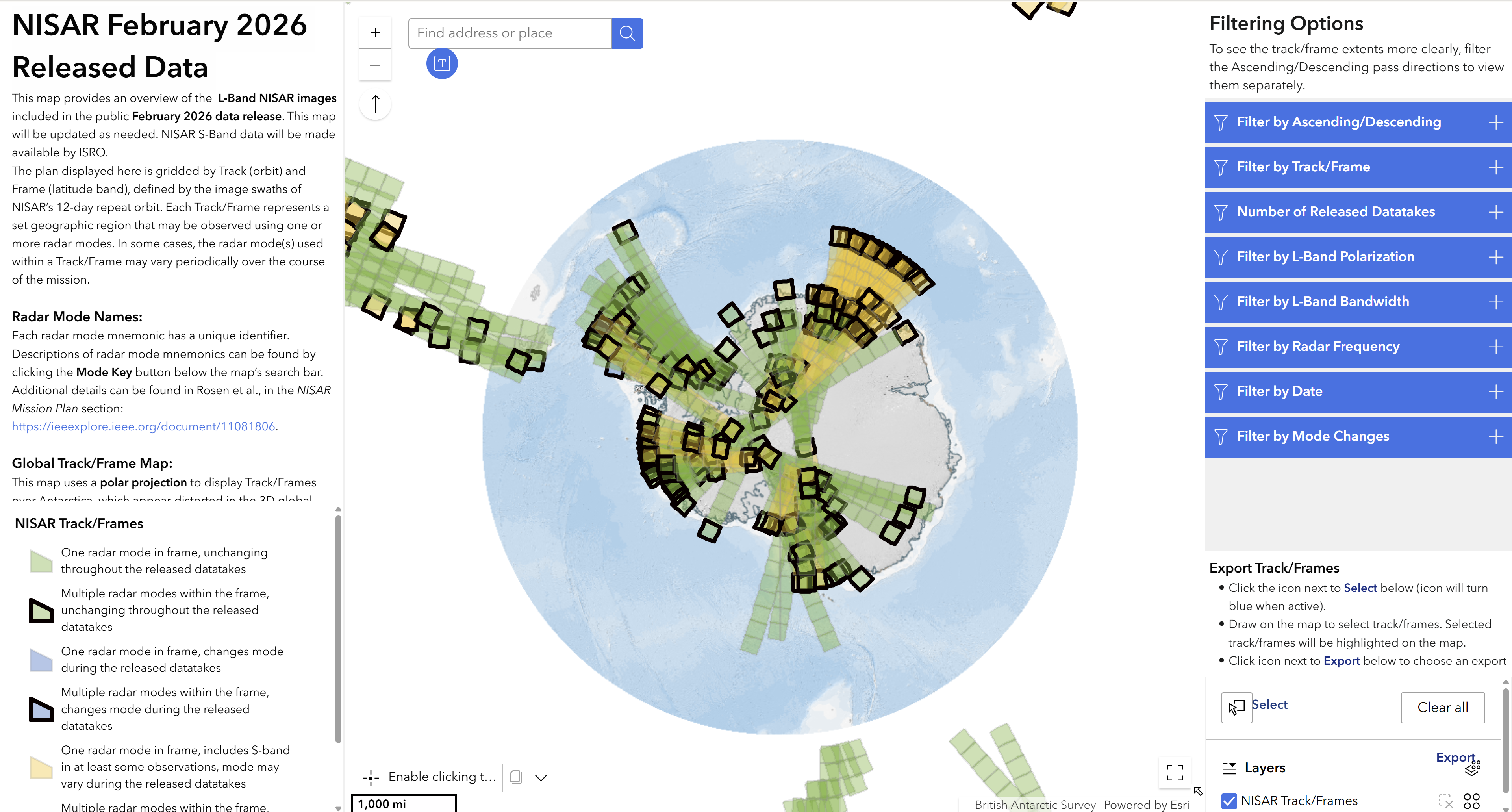
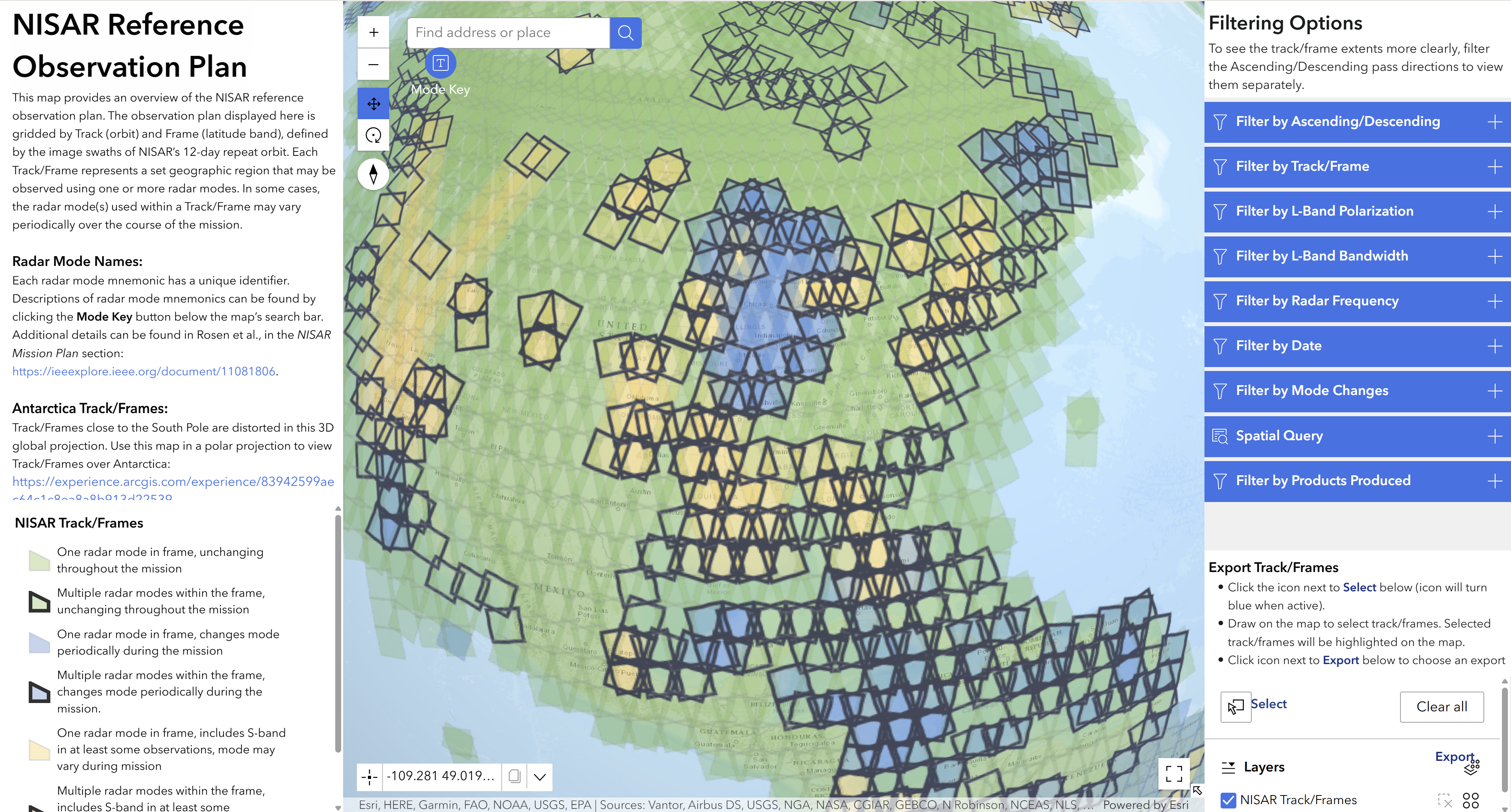
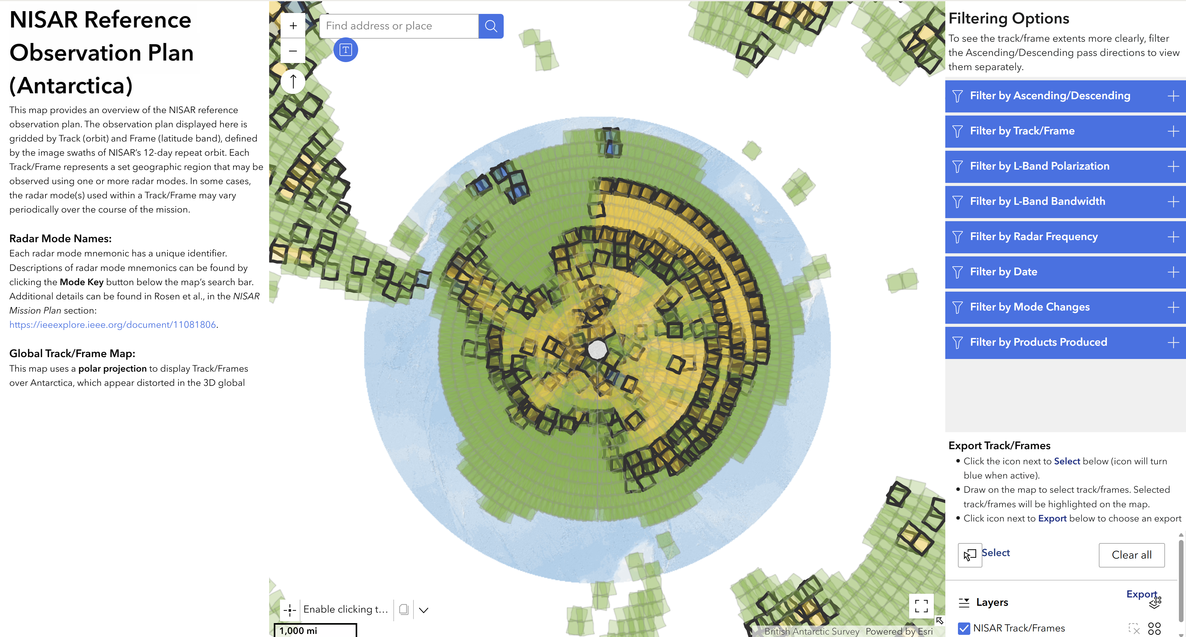
For each data extent (pre-calibration data or reference observation plan), there are two different apps. One is suitable for viewing most of the globe, while the other is optimized for viewing acquisitions over Antarctica. The apps optimized for Antarctica use a south polar stereographic projection to improve the rendering of frame footprints.
Pre-Calibration Data Apps
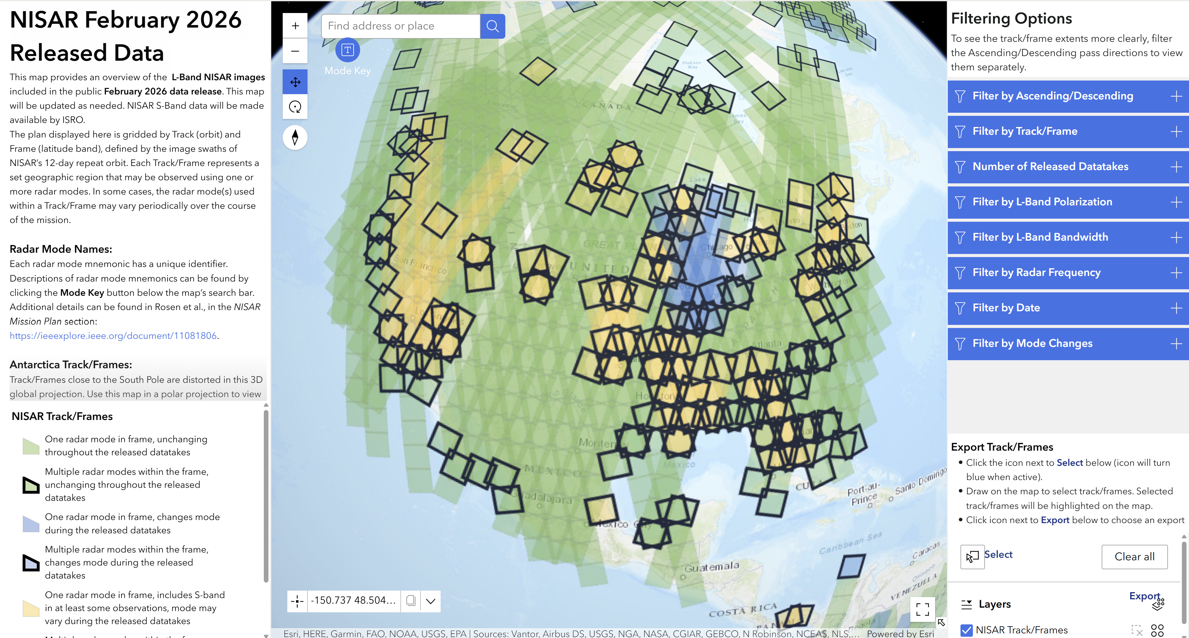
These applications provide an overview of the L-band NISAR images included in the NISAR Pre-Calibration Data: February 2026 data release. Click an app image or header to open it in a new tab.
NISAR February 2026 Released Data - Global
NISAR February 2026 Released Data - Antarctic
Reference Observation Plan Apps
These applications provide an overview of the L-band NISAR acquisitions that will be available once calibrated data is released.
NISAR Reference Observation Plan - Global
NISAR Reference Observation Plan - Antarctic
- NISAR. (2025). NASA-ISRO SAR (NISAR) Mission Science Users’ Handbook, Second Edition (Second Edition). NASA Jet Propulsion Laboratory. 10.48577/jpl.UD4HV3