Data Products Overview
There are a range of data products generated by the NISAR mission team that are archived and available for immediate use, from raw data to analysis-ready products.
One of the most exciting aspects of the NISAR mission is that it generates a number of analysis-ready SAR datasets. These Level 2 (Geocoded) and Level 3 (Geophysical) products are archived and freely available to the public. This allows users without the software or expertise necessary to process SAR data easy access to products that can be used in analysis workflows.
For SAR scientists and those who want to generate products to their own specifications, the Level 0 (Raw) data and Level 1 (Range-Doppler) products are also available.
NISAR Maturity Levels
NASA uses different data maturity levels for data generated over the duration of a mission. There are currently NISAR datasets for two different maturity levels available:
The BETA collections include products from the first two releases of NISAR data in January 2026 and February 2026. These products are not fully calibrated, and exhibit a number of known issues, but are still useful for those who would like to access products from earlier in the mission.
The PROVISIONAL collections include products from the July 2026 release. These products are fully calibrated and partially validated, but processing improvements are still underway.
Provisional products will be continuously added to the archive as new data is acquired, until the validation period is complete and the reprocessing campaign is launched to generate validated products from the start of the science phase of the mission onwards.
These provisional products are available for acquisitions starting June 17, 2026.
The BETA products and PROVISIONAL products do not overlap temporally, so some users who want to access the data from earlier in the mission may still find the BETA products useful. Because of updates to the processing software to improve product quality, use caution when including both BETA and PROVISIONAL products in analysis workflows. Differences between products from the different maturities may be due to differences in the processing workflow rather than actual changes on the landscape.
NISAR Product Levels
The NASA processing levels used for SAR have somewhat different meanings than those used for multi-spectral (optical) imagery. We will summarize these processing levels and the specific products generated by the mission at each level and provide links to additional information about each product type.
Figure 1 illustrates the products that will be generated in association with the NISAR mission, indicating the products used as input. Level 0 through Level 2 products will be produced directly by the mission and archived at ASF, as will the Level 3 Soil Moisture products.
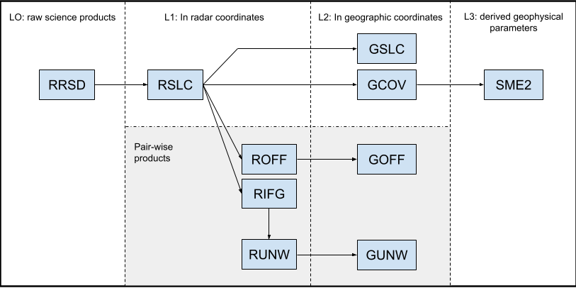
Figure 1:NISAR Data Product Levels based on product specification documentation
Additional Level 3 and 4 products will be produced by the NISAR science team, but only for specific areas used for calibration and validation activities. Some of these cal/val products may be archived and available to the public. The algorithms for these higher-level products are available as Python notebooks, allowing users to generate these scientific products themselves for other locations.
Level 0: Unfocused Raw Products
Level 0 products are unprocessed instrument data. L0A products are the received raw data, which are archived for reference but are not of use to the scientific community. L0B products have been processed to remove transmission artifacts, and are the starting point for processing all additional mission products. They are generally only of interest to SAR scientists.
The Radar Raw Signal Data (RRSD) L0B product contains corrected, aligned radar pulse data.
Level 1: Range-Doppler Products
Level 1 products are processed instrument data, focused to full resolution complex images. They are time referenced and annotated with ancillary information, including radiometric and relevant geometric calibration coefficients and georeferencing parameters (i.e. platform ephemeris). Level 1 products are in natural radar coordinates, and cannot be directly overlaid on a map.
The Range-Doppler Single Look Complex (RSLC) product contains focused SAR images in range-Doppler coordinates. Other pair-based Level 1 products are derived from this product.
The Range-Doppler Interferogram (RIFG) product represents the ellipsoid height-corrected, wrapped interferogram generated from two RSLCs in range-Doppler coordinates. The RIFG product is primarily meant for detecting grounding lines.
The Range-Doppler Pixel Offsets (ROFF) product represents a collection of dense pixel offsets layers obtained from applying speckle tracking to a pair of coarsely coregistered RSLCs in range-Doppler coordinates. The ROFF product is primarily meant for cryosphere applications.
The Range-Doppler Unwrapped Interferogram (RUNW) product represents the unwrapped, multi-looked differential interferogram generated from two RSLCs in range-Doppler coordinates. The RUNW product primarily supports the solid earth requirement of ground surface displacement measurements.
Level 2: Geocoded Products
Level 2 products are derived from Level 1 products, resampled and geocoded to a geographic grid. They can be directly overlaid on a map and combined with other data in geographic coordinates.
The Geocoded Single Look Complex (GSLC) product represents the single look complex signal return for each polarization in geographic coordinates. The GSLC product enables users to perform backscatter amplitude analysis, and can be combined with other similar GSLC products to derive interferograms and change maps.
The Geocoded Pixel Offsets (GOFF) product represents a collection of dense pixel offsets layers obtained from applying speckle tracking to a pair of coarsely coregistered RSLCs in geographic coordinates. The GOFF product is primarily meant for cryosphere applications.
The Geocoded Polarimetric Covariance Matrix (GCOV) product provides radiometrically terrain corrected SAR backscatter data to primarily support the NISAR ecosystem requirements of biomass estimation, soil moisture estimation, disturbance detection, inundation mapping, and crop area delineation.
The Geocoded Unwrapped Interferogram (GUNW) product represents the unwrapped, multi-looked differential interferogram generated from two RSLCs in geographic coordinates. The GUNW product primarily supports the solid earth requirement of ground surface displacement measurements.
Level 3: Geophysical Products
Level 3 products represent geophysical parameters derived from radar-specific parameters and geocoded to a geographic grid.
The Soil Moisture (SME2) product contains soil moisture estimates derived from NISAR data using three different algorithms at agricultural field-scale (200m) posting for most regions (the Sahara Desert will be at 500m). Soil moisture information can be used for reservoir management, early warning of droughts, irrigation scheduling, and crop yield forecasting.
Summary
The table below summarizes the characteristics of NISAR data products.
Table 1:NISAR data product overview
| Product | Ground spacing [m] | Interferometric | Geocoded | Layers | Additional layers | Comments |
|---|---|---|---|---|---|---|
| RSLC | NA | individual binary raster layers representing complex signal return for each polarization layer | 2D LUTs provided to convert from digital numbers to beta-naught, sigma-naught, and gamma-naught | zero-Doppler geometry, constant azimuth time interval and one-way slant range spacing | ||
| GSLC | 5 to 40* | ✔ | input RSLC into a geocoded map coordinate system | 2D LUTs provided to convert from digital numbers to beta-naught, sigma-naught, and gamma-naught; mask layer indicating water bodies and shadow-layover | flattened with respect to the orbit used in the RSLC processing, which eliminates the topographic phase contribution in the GSLC | |
| ROFF | 90 | ✔ | along-track offset, slant range offset (three layers) | offset variances, correlation surface peak, cross offset variance, signal-to-noise ratio | distributed without performing any conventional post-processing operation i.e., layers might contain offsets outliers and are not low pass filtered to reduce noise in the data | |
| GOFF | 80 | ✔ | ✔ | along-track offset, slant range offset (three layers) | offset variances, correlation surface peak, cross offset variance, signal-to-noise ratio | distributed without performing any conventional post-processing operation i.e., layers might contain offsets outliers and are not low pass filtered to reduce noise in the data |
| RIFG | 30 | ✔ | wrapped interferogram | coherence magnitude | ellipsoid and topography flattened, multi-looked | |
| RUNW | 80 | ✔ | unwrapped interferogram | coherence magnitude, connected components, ionospheric phase screen, ionospheric phase screen uncertainty | ellipsoid- and topography-flattened, multi-looked | |
| GUNW | 80 | ✔ | ✔ | unwrapped interferogram | coherence magnitude, connected components, ionospheric phase screen, ionospheric phase screen uncertainty | interpolation method during geocoding depends on layer data type |
| 80 | ✔ | ✔ | wrapped interferogram | |||
| GCOV | 20 | ✔ | polarimetric covariance terms | mask, number of looks, RTC gamma to sigma factor | radiometrically terrain-corrected gamma-naught | |
| SME2 | 200 | ✔ | three soil moisture estimates: disaggregation (DSG), physical model inversion (PMI), time series ratio (TSR) | soil moisture uncertainty, DSG algorithm parameters, PMI crop type and vegetation water content, TSR algorithm parameters |
depending on range bandwidth