Product Specification Find Data
Product Overview
Geocoded Polarimetric Covariance (GCOV) products provide calibrated backscatter measurements corrected for both radiometric and terrain distortions, presented as gamma-0 power values. For users familiar with other corrected SAR amplitude products, these data can be used like Normalized Radar Backscatter (NRB) or Radiometrically Terrain Corrected (RTC) products.
Due to the side-looking nature of NISAR, topography can significantly affect the magnitude of backscatter, with areas facing the sensor becoming artificially “brighter” (returning higher backscatter) than expected, which biases covariance measurements. To mitigate the effect of topography, an area-based RTC is applied to the covariance terms, normalizing the backscatter. The reference digital elevation model (DEM) for processing and RTC is based on the Copernicus 30-m and 90-m DEM. These normalized terms are then geocoded to the output grid using area-based adaptive multi-looking.
GCOV products are projected to the appropriate UTM zone for their location and have a pixel spacing of 10 or 20 meters, depending on the acquisition location. They can be used directly in geospatial analysis platforms and workflows. Each product includes a covariance variable for each polarization available from the acquisition.
Product Specification
A complete description of NISAR GCOV products is available in Shiroma (2024).
Data Layers
A GCOV data product includes the following raster data sets. Complete descriptions of these data layers are available in Shiroma (2024, Section 4.3).
Geocoded Polarimetric Covariance Terms
/science/LSAR/GCOV/grids/frequency[A|B]/HHHH /science/LSAR/GCOV/grids/frequency[A|B]/HVHV /science/LSAR/GCOV/grids/frequency[A|B]/HHHV /science/LSAR/GCOV/grids/frequency[A|B]/HHVH /science/LSAR/GCOV/grids/frequency[A|B]/HHVV /science/LSAR/GCOV/grids/frequency[A|B]/HVVH /science/LSAR/GCOV/grids/frequency[A|B]/HVVV /science/LSAR/GCOV/grids/frequency[A|B]/VVVV /science/LSAR/GCOV/grids/frequency[A|B]/VHVH /science/LSAR/GCOV/grids/frequency[A|B]/VHVV /science/LSAR/GCOV/grids/frequency[A|B]/RHRH /science/LSAR/GCOV/grids/frequency[A|B]/RVRV /science/LSAR/GCOV/grids/frequency[A|B]/RHRV
The primary data elements of the GCOV product are the images of the geocoded polarimetric covariance terms. Visit Polarimetry (2025) to learn more about NISAR polarimetry.
The diagonal terms shown in Figure 1 (HHHH, HVHV, VVVV, VHVH, RHRH, RVRV) are real-valued and describe the intensity of the radar backscatter for the given polarization.
The remaining terms shown in Figure 1 (HHHV, HHVH, HHVV, HVVH, HVVV, VHVV, RHRV) are complex-valued and describe the intensity and phase between different polarizations. These off-diagonal terms are only included for quad-pol data acquisitions. Users who require off-diagonal values for dual-pol acquisitions will need to generate these layers manually from GSLC products.
The frequencies and polarizations available in a particular GCOV data product will vary based on the acquisition mode used to collect the data.
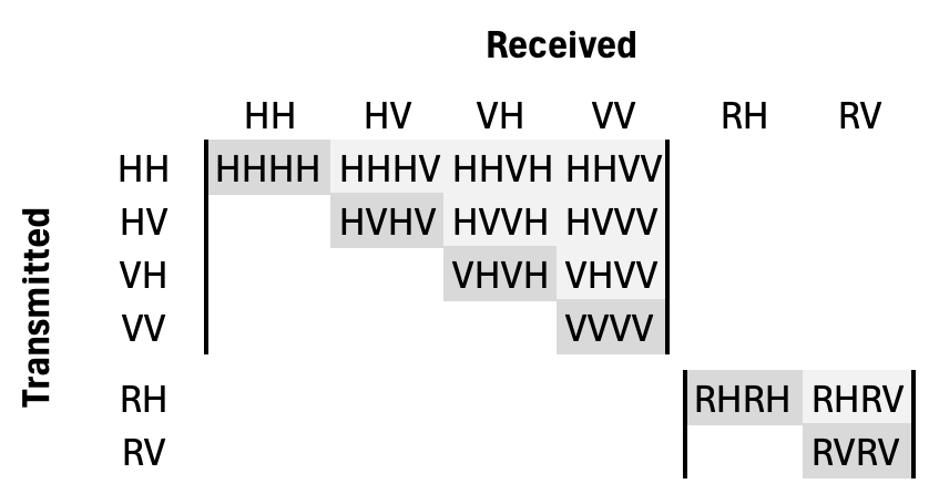
Figure 1:Matrix of the possible polarizations available in NISAR GCOV products. Products provided for any of the combinations on the diagonal (highlighted in dark grey) are formatted with real-valued float values, while any of the products provided from above the diagonal (highlighted in light grey) are formatted with complex values.
Number of Looks
/science/LSAR/GCOV/grids/frequency[A|B]/numberOfLooks
The GCOV terms are obtained from the geocoding of the RSLC product polarimetric covariance terms using an adaptive area-based multi-looking algorithm. The multi-looking window and number of averaged looks vary with the topography and radar geometry.
The number of looks layer provides the number of looks used for computing each GCOV term sample.
Mask
/science/LSAR/GCOV/grids/frequency[A|B]/mask
The mask layer provides information about the averaging ensemble of radar samples that originated the GCOV terms through adaptive multi-looking.
Radiometric Terrain Correction Gamma-to-Sigma Factor
/science/LSAR/GCOV/grids/frequency[A|B]/rtcGammaToSigmaFactor
The RTC Gamma-to-Sigma factor provides factors to normalize the backscatter normalization convention of the GCOV matrix from gamma0 to sigma0.
Naming Convention
NISAR GCOV product names will conform to the following naming convention:
NISAR_IL_PT_PROD_CYL_REL_P_FRM_MODE_POLE_S_StartDateTime_EndDateTime_CRID_A_C_LOC_CTR.EXT
Hover over a term listed above to see its description, or click on a specific segment to skip to its description below. Refer to Figure 1 in the Naming Conventions section to see a diagram.
- NISAR
- 5 characters for the Mission
NISAR
- I
- 1 character for the Instrument used for the acquisition
L: L-band SAR
S: S-band SAR
- L
- 1 character for the product processing Level (1/2/3)
GCOV products are Level 2
- PT
- 2 characters for the Processing Type
PR: Production
UR: Urgent Response
OD: Science On-Demand
- PROD
- 4 characters for the PRODuct Identifier
GCOV
- CYL
- 3 characters for the CYcLe number in the mission
each cycle represents 12 days
zero padded
starting at 001
- REL
- 3 characters for the RELative orbit track number within a cycle
resets to 1 with a cycle number increment
zero padded
valid values: 001-173
- P
- 1 character for the Orbit Direction (direction of movement of the satellite at the time of imaging)
A: Ascending
D: Descending
- FRM
- 3 characters for the track FRaMe number
a segment of an orbital track corresponding to the product
zero padded
valid values: 001-176 on each track
- MODE
- 4 characters for the Bandwidth MODE Code of the Primary and Secondary Bands
first two characters for primary band, last two for secondary band
Possible values: 40, 20, 77, 05, or 00
00 only used if the secondary band is missing
- POLE
- 4 characters for the Polarization of the data for the primary and secondary bands respectively. Each band uses a two character code among the following:
SH = HH – Single Polarity (H transmit and receive)
SV = VV – Single Polarity (V transmit and receive)
DH = HH/HV – Dual Polarity (H transmit)
DV = VV/VH – Dual Polarity (V transmit)
CL= LH/LV – Compact Polarity (Left transmit)
CR = RH/RV – Compact Polarity (Right transmit)
QP = HH/HV/VV/VH – Quad Polarity
NA if band does not exist
- For example:
a single-pol H-primary polarization mode would be SHSH
a dual-pol V-primary polarization mode would be DVDV
a “quasi-quad” polarization mode would be noted DHDV
a “quasi-dual” polarization mode would be noted SHSV
- S
- 1 character for the Source of data for the product
A: Acquired source of the observation, single mode
M: Mixed source of observations, mixed mode
- StartDateTime
- 15 chars for Radar Start Date/Time of the data processed as zero Doppler
Format: YYYYMMDDTHHMMSS, UTC
- EndDateTime
- 15 chars for Radar End Date/Time of the data processed as zero Doppler
Format: YYYYMMDDTHHMMSS, UTC
- CRID
- 6 characters for the Composite Release IDentifier
indicates the version of the workflow used to process the data, incorporating a number of software and project versions
Format of EPMMmm
MMmm indicates the major and minor version numbers
- A
- 1 character for the Product Accuracy or Fidelity of the Orbit Ephemeris and Radar Pointing:
P: Precise
M: Medium
N: Near Real-Time
F: Forecast
- C
- 1 character indicating Coverage of the frame
F: Full
P: Partial
- LOC
- 1 character to represent the Location of the Science Data System
J: JPL
- CTR
- 3 characters for product CounTeR
zero padded
- EXT
- 1 to n characters for Extension
h5
met
log
Finding Data
GCOV products can be found in Vertex by setting the Dataset filter to “NISAR” and the Science Product filter to “GCOV (Geocoded Polarimetric Covariance)”: Find Data in Vertex
GCOV products can be found in Earthdata Search by searching for “NISAR_L2_GCOV_”: Find Data in Earthdata Search
- Shiroma, G. H. X. (2024). Level-2 Geocoded Polarimetric Covariance (NASA SDS Product Specification JPL D-102274 (Revision E)). NASA Jet Propulsion Laboratory. https://nisar.asf.earthdatacloud.nasa.gov/NISAR-SAMPLE-DATA/DOCS/NISAR_D-102274_RevE_NASA_SDS_Product_Specification_L2_GCOV_Nov8_2024_w-sigs.pdf
- Polarimetry. (2025). https://science.nasa.gov/mission/nisar/polarimetry/